Saturday, 23 March 2013

Time Lapse


This week we have received two enquiries from construction and facility management companies regarding time lapse photography.  Both companies have major construction projects planned for the forthcoming weeks / months ahead and would like to record site progress from the first cut of soil to the completed structure.
The use of  time-lapse photography can benefit the project manger in many ways, from site progress development to time management.
Our cameras record still frames greater than HD video and are rendered at 25 frames per second to a seamless film covering the total build time on site.

We can cover one day events through to prolonged builds and have a tariff to suit all needs from a single camera through to multi camera setups.
Click on the link below to view a very simple one camera set up.

  To view demo click HERE

Friday, 8 March 2013

New arrival at quarry

Today in the wind, rain and freezing cold we were onsite at one of Northern Irelands leading quarry companies.
Our client has recently heavily invested in some new trucks of all shapes and sizes.  Several images were required for the company PR for both our client and the Donnelly Group.
Just as we set up for this shot, the first shot of the day, the heavens opened.  Needless to say the shoot was over very very quickly. But not before getting what we needed.

New addition to the fleet

Monday, 4 March 2013

Hotel Bedroom view

Just recently we have been working with a client who has the foresight for one of the best ever Hotel golf and spa resorts right here in Co Down.
We have been on site today capturing the sweeping hills before construction work begins.  Our brief was to show the view from the hotel bedroom, which of course has yet to be built.  However in the pano image below this is the wonderful view you can expect to see.
If this goes ahead Northern Ireland will have a golf-course to boast about.
This photograph is made up of five stitched images taken at a height of 40mts AGL using our UAV.

View from Hotel bedroom

Sunday, 3 March 2013

Aerial filming - Causeway Coast

For those who are following our progress on aerial filming and aerial photography work will be aware that the Causeway Coast is part of a client requirement to promote Northern Ireland as a tourist destination, second to none.  
The brief for the stones from the Art Director was simple. "The stones, are the Causeway coast so we want to see definition of the stones in the aerial footage".  That was basically it, apart from you have to fly low- very low, the deadline and the fact that it had to be captured in sunshine.
On Friday past if you just happened to be at the Causeway on a beautiful day you certainly saw us and our crew with the UAV filming the coast line, with of course the permission from the National Trust.
Following the directors brief, the aerial video and photography will show the stones in all their glory and we've taken to screen shots from the video just to show that.
From what I have seen so far, this footage is a jaw dropper.  I just you think so too.
Soon to be screened on TV.


Screen shots from the aerial footage of the causeway stones, Co Antrim

Causeway stones - National Trust property

Wednesday, 20 February 2013

Air to Air

Our last post related to Ground to air photography.  Isn't is strange that only this week we're now shooting air to air.
Using two helicopters we covered some aspects of the Robinson 22 flight.  A great day out was had by all.


Robinson 22 North Antrim

Monday, 18 February 2013

A sunny change, Belfast

Whist we specialise in aerial photography, air to ground, sometimes we get a commission in reverse, ie ground to air.  Today was no exception.
We are currently working on a commercial brochure showing the transportation infrastructure of Northern Ireland.  Some of the images planned require shots of aircraft either landing or taking off. So today being the best day of the year so far we did just that.


Wednesday, 13 February 2013

Progress flights for road mapping

Currently there are a number of road construction projects throughout the province.  Generally in days gone by, we've boarded a Cessna, flew to our destination and followed the roadway at 1500 ft, taking photographs along the route.  The results at that time were and still are great. One of the drawbacks however would be the inconsistency of the photographs throughout the construction progress. The variation in height/distance, aircraft placement, unfamiliar pilot etc meant the every run was slightly different.
However in the age of technology we do things a little different now.  We use the UAV, Unmanned aerial vehicle.
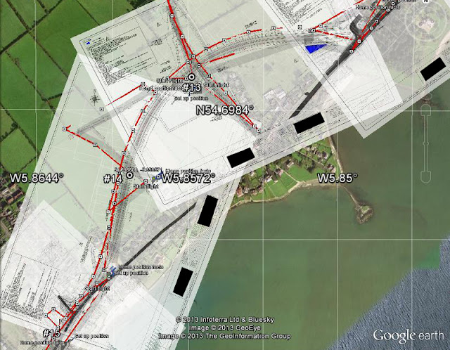
Planning a route which takes in to account the project managers specifications we offer very detailed vertical images from a height from ground level to, in-fact, any height up to 126mts AGL. Images which are not achievable from the standard Cessna or Robinson 44 due to aircraft construction, wheels, spats struts, got in the way, never mind the low fly rule. If 45* obliques are required its only a matter of adding an additional photography task at each waypoint.
The UAV flight is silent, so no noise complaints from residents and the results, quick and accurate.
At the planning stage our maps are over-layed with the constructors/surveyor detailed plans, using very sophisticated software and from there a flight plan can be designed, which takes into account buildings bridges footpaths etc.  The UAV course will be exactly the same for each and every-time we are required to revisit making progress locations exactly the same.
On site, the flight is conducted by our CAA / IAA qualified staff with the minimum of disruption. During the post processing highly detailed images are stitched together to form an aerial plan view of the construction site.
Full 4K route

Close up of area
In the above examples, a new carriageway is to be constructed through farmland. As you can see we have overlayed the original ground map with survey plans for the road and structure construction.  From that, a flight path has been created.  The markers show where the vertical photographs will be taken.
Now you have no excuse to have those highly detailed vertical images at a cost which is affordable.
For a free quotation please do discuss the flight with our staff.